
(End of the American Dream)—What happens when two massive hurricanes collide? It looks like we are about to find out. Hurricane Polo and Hurricane Odalys are heading directly toward one another. Meteorologists have some theories about what will happen as they slam into one another, but nobody really knows. Meanwhile, Tropical Storm Nolo is poised to become Hurricane Nolo.
We are being told that it could drop several feet of rain on some parts of Hawaii. Of course the east coast is not being left out of the chaos either. An absolutely huge nor’easter is already causing severe flooding on the east coast. We were anticipating that we would see some absolutely crazy weather this fall, and that is exactly what we are getting.
Hurricane Polo has been absolutely shocking the experts for days.
It went from being a weak tropical storm to a Category 5 hurricane in just 24 hours.
On Thursday, it dropped down to a Category 4 storm, but we were being told that some “near-term strengthening is possible”…
Hurricane Polo’s intensity oscillated between Category 4 and Category 5 on Thursday as its path started moving away from Mexico’s southwestern coast. The storm was expected to remain offshore, while its outer rainbands spread across southwestern Mexico, the U.S. National Hurricane Center said.
“Some near-term strengthening is possible, and Polo is expected to remain a powerful major hurricane for the next few days,” the Miami-based center said.
That forecast turned out to be accurate, because now it appears that Hurricane Polo is about to strengthen into a Category 5 storm for a third time…
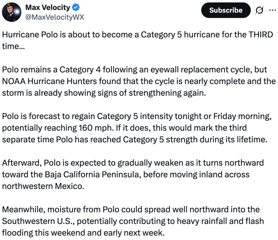
There is nothing about Hurricane Polo that is normal.
The rate at which it originally intensified into a very powerful hurricane stunned everyone, and it ultimately became the second most powerful storm ever recorded in the Eastern Pacific…
Its intensification was dramatic even by those standards, with winds that skyrocketed from 45 mph early Monday morning to 150 mph at around the same time the following day. The hurricane center described its transformation as “truly remarkable.”
Its maximum sustained winds climbed as high as 180 mph at one point, far exceeding the 157 mph threshold for Category 5, the strongest on the hurricane scale.
Polo’s central pressure — an indicator of its strength and potential destructiveness — made it the second-strongest hurricane on record in the Eastern Pacific, behind 2015’s Hurricane Patricia. The storm’s wind speeds tied 2009’s Hurricane Rick as the third-strongest on record for the region.
In addition, a temperature reading that was actually taken inside the eye of Hurricane Polo matched an all-time record that was established by Hurricane Rita all the way back in 2005…
The flight-level temperature reading inside Polo’s eye on Tuesday “tied Hurricane Rita’s in 2005 for the warmest on record, surpassing even some of the most intense western Pacific Super Typhoons ever directly observed like Megi in 2010,” Lowry wrote, crediting Derrick Herndon, a hurricane researcher at the University of Wisconsin-Madison’s Cooperative Institute for Meteorological Satellite Studies.
“Simply put, the amount of latent heat being released inside the core of Polo from the intense ring of thunderstorms surrounding its eye (the notorious eyewall) was exceptional, a rare show of force from Mother Nature when everything aligns to form one of the most powerful storms on Earth,” Lowry wrote.
Everything about this storm seems designed to get our attention.
And now Hurricane Polo is on a collision course with another hurricane.
Hurricane Polo is currently headed in a northwesterly direction and that will take it right into the path of Hurricane Odalys…

Cat. 5 Hurricane Polo is moving northwest off the coast of Mexico towards Baja California where it’s expected to interact with Cat. 1 Hurricane Odalys. Interactions between cyclones where they begin to rotate around a common center point begin around 1400 km (870 miles) apart.
Many meteorologists think that Odalys will fizzle out as it encounters Polo.
But Philippe Papin, a senior hurricane specialist at the National Hurricane Center, is warning that there is a possibility that Hurricane Odalys could actually “pull Polo further to the north”…
To the west of Polo, Hurricane Odalys was spinning over the Pacific Ocean. While this storm was not expected to approach land, it could interact with Polo.
“It might pull Polo further to the north, while Odalys could be pulled to the south,” Papin said. “It depends on how close they get together and the overall intensity of those circulations.”
That is a major bombshell.
Right now, we are being assured that Hurricane Polo will make landfall somewhere along the Baja peninsula…
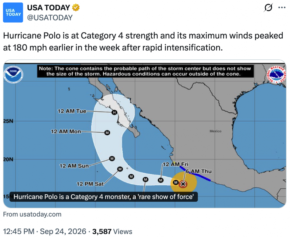
But if Hurricane Polo gets pulled “further to the north”, it could bypass the Baja peninsula altogether.
In such a scenario, there is a possibility that it could actually make landfall in California.
Needless to say, that would be a truly monumental event.
At the same time, Tropical Storm Nolo is getting stronger as it heads toward Hawaii…
Hawaii’s Big Island is under a hurricane watch as Tropical Storm Nolo strengthens in the Pacific Ocean, threatening to dump up to 3 feet of rain on the island this week, the National Hurricane Center said.
Nolo formed Wednesday and could become a hurricane by Thursday night, around the time heavy rainfall on the Big Island could also begin, forecasters said. They also warned that the storm could become a major hurricane by the weekend, meaning a Category 3 or higher.
This is also a very serious storm.
At this stage, even Accuweather is warning that Nolo could potentially do even more damage than Hurricane Lala did…
Hawaii is facing its biggest tropical threat so far this hurricane season with newly named Tropical Storm Nolo forecast to become a Category 3 storm as it nears the Big Island into the weekend.
The impacts could be even more severe than Hurricane Lala, which left residents of the Big Island in “total shock” due to the magnitude of the damage. Communication was cut off for some areas, with the hardest-hit areas of Hawaii being without power for over a week.
Friday and Saturday are expected to be the critical days for this storm.
Maui is expected to get about 20 inches of rain and the Big Island is expected to get up to 35 inches of rain in some areas.
But if a worst case scenario materializes, Accuweather says that up to 55 inches of rain is possible…
Rainfall totals could reach as high as 35 inches at higher elevations on the Big Island and 20 inches on Maui, much of it at excessive rainfall rates that will make flooding likely, according to hurricane center forecasts.
“This rainfall may produce catastrophic life-threatening flooding and mudslides, especially in areas of steep terrain,” the hurricane center said in a forecast late Wednesday night Hawaii time.
A forecast from AccuWeather says that as much as 55 inches of rain is possible from Nolo, which could rival Hawaii’s all-time highest rainfall total from a tropical cyclone. The record now belongs to Hurricane Lane, which dumped 58 inches on the Big Island in 2018.
I can’t even imagine what that much rain would look like.
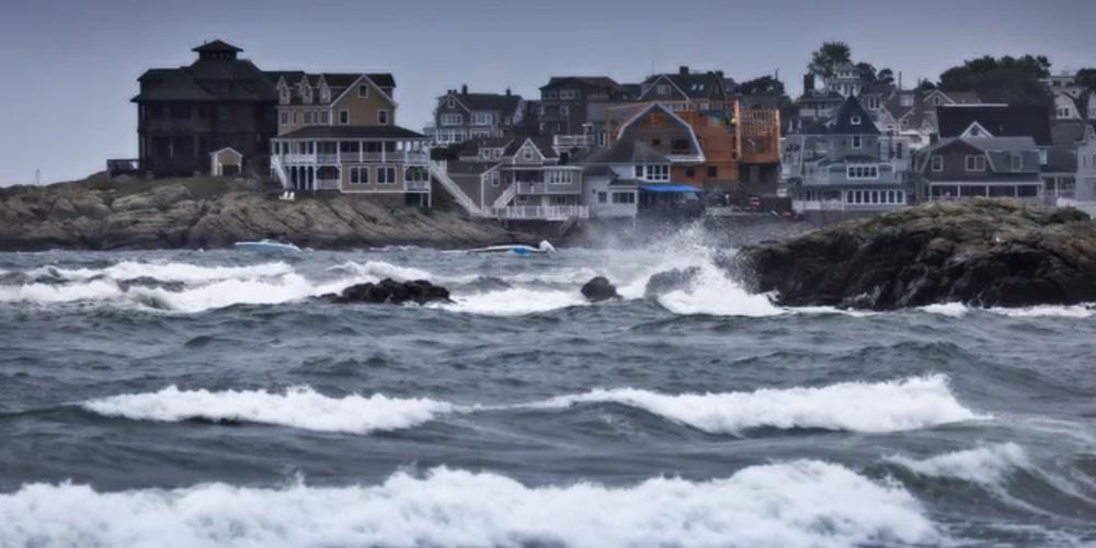
On the east coast, a very scary nor’easter is going to create all sorts of chaos in the days ahead.
It is technically not a hurricane, but in many ways it is acting like one.
In fact, we are being told that models are projecting that it will develop “a giant eye at its center by Saturday”…
Millions of Americans have been warned to prepare now as a massive storm approaches the East Coast.
Meteorologists are monitoring a nor’easter, a strong storm off the US coast in the Atlantic, expected to slam into the Northeast in just hours, bringing heavy downpours, coastal flooding, tropical storm-force winds and power outages from Virginia to Maine.
Weather models tracking the nor’easter show it developing a giant eye at its center by Saturday, a formation similar to those seen in hurricanes.
This storm is going to cause so much flooding.
In fact, severe coastal flooding has already started in Virginia…
Flooding began on Wednesday morning in Norfolk, Virginia, where 1 to 2 feet of seawater inundated coastal areas. Rain compounded the tidal flooding, according to AccuWeather Reporter Leslie Hudson, who was covering the storm’s impacts in southeastern Virginia.
“You can’t get through with low-profile vehicles,” Hudson said on Wednesday evening along a flooded road in Norfolk. To add to the dangers, it wasn’t just water in the streets. “There’s also some fire ant flotillas. There’s also gasoline. There’s also oil. Several of the cars that have flooded out, of course, are leaking fluids. So altogether it’s just not a great recipe.”
We haven’t seen a storm of this magnitude on the east coast in quite a while.
Meteorologists are expecting that New England will get hit the hardest…
The heaviest impacts are predicted throughout New England, hitting Connecticut, Rhode Island, Massachusetts, New Hampshire and southern Maine with winds potentially reaching 70 mph and four to eight inches of rain in many areas.
AccuWeather Chief Meteorologist Jon Porter warned in a statement: ‘This storm may be remembered for its destructive coastal flooding and severe beach erosion, especially along eastern Long Island and the Massachusetts coast.’
Coastal flood warnings have been issued in New York, New Jersey, Delaware, Maryland and Virginia on Thursday, with the National Weather Service (NWS) saying that over three feet of water from the sea will be pushed onto land in these areas.
If you live on the east coast, please take this storm very seriously.
If you live in Hawaii, please stay inside this weekend.
And if you live in California, I would suggest watching the path of Hurricane Polo very closely.
The weather has become very “interesting” during the second half of 2026, and I am convinced that a lot more surprises are still ahead.
Michael’s new book entitled “10 Prophetic Events That Are Coming Next” is available in paperback and for the Kindle on Amazon.com, and you can subscribe to his Substack newsletter at michaeltsnyder.substack.com.
Two Storms, One Harvest

Every food crisis in living memory has been a one-shock event. The 2008 price spike was a commodity bubble. The 2020 shortages were a logistics failure. The 2022 grain scare was a war on one exporter’s ports. Each time, the system bent, adjusted, and recovered, and each time the experts assured us afterward that global markets are simply too big and too diversified to fail.
What nobody in Washington seems eager to discuss is that 2026 is shaping up to be something the modern food system has never actually faced. Two independent shocks, one climatic and one geopolitical, are converging on the same harvest cycle at the same time. Not sequentially. Simultaneously.
Start with the weather. The Pacific Ocean is currently building toward what forecasters now openly call a record event. NOAA’s Climate Prediction Center puts the odds of at least a strong El Niño near 88 percent, with roughly two in three odds it reaches “very strong” status, the tier reserved for perhaps three or four events in the entire satellite era. Every major global model now projects a median peak in Super El Niño territory, and most of them project it exceeding the 2015-16 event, which until now held the modern record. Sea surface anomalies were already brushing the super threshold in mid-July, months before these events normally peak. The atmosphere has already shifted into El Niño mode, and the event is forecast to crest in late fall and early winter.
This is not about “climate change.” It’s about the standard cycles of weather, and the cycle we’re currently in is one that has likely devastated societies in the past. We’re better prepared as a society today, but not all Americans are equally prepared.
Serious households have started doing the quiet math on their own. Grocery bills tell part of the story, and the forecast maps tell the rest, which is why long-term food storage has moved from fringe hobby to mainstream line item in the family budget, with established suppliers like Heaven’s Harvest seeing demand from people who five years ago would have rolled their eyes at the idea. That instinct is not paranoia. It is pattern recognition, and the pattern is worth walking through carefully.
Editor’s Note: Heaven’s Harvest IS a sponsor, but the warnings of this article are real and would be written even if we didn’t have a survival food sponsor. With that said, those who take advantage of what they offer can use promo code “Patriot” for 15% off.
The Fertilizer Clock Is Already Running
While the Pacific warms, the second shock has been unfolding in the Strait of Hormuz. The conflict with Iran turned the world’s most important energy chokepoint into a contested waterway, and the consequences reach far beyond the gas pump. Roughly a third of global fertilizer trade moves through Hormuz, and the disruption sent urea prices up 86 percent year over year by March, with a 53 percent jump in a single month.
The World Bank projects energy prices rising about 24 percent in 2026 and fertilizer about 31 percent. By its own accounting, fertilizer prices ran 35 percent higher in the first five months of this year than the same period last year.
Here is the mechanism the nightly news will not explain. Fertilizer is not a grocery item. It is a time-delayed input. The nitrogen a farmer in Iowa or Punjab could not afford to apply this spring does not show up as a problem this spring. It shows up as a thinner harvest six to twelve months later.
The World Bank’s own food security brief concedes that the effects of reduced applications earlier this season “are likely to become visible only later in harvest outcomes.” Translate that from institutional language into plain English and it means this. The damage is already done, it is already in the ground, and we are simply waiting for it to arrive on the shelf.
Now check the calendar. Six to twelve months from the spring planting season lands us squarely in late 2026 and early 2027. Which is precisely when the strongest El Niño in the instrumental record is forecast to peak, bringing its signature droughts to Southeast Asia, Australia, southern Africa, northern Brazil, and South Asia, the very regions that grow the world’s rice, sugar, and oilseeds.
The World Bank warns openly that a strong El Niño “could disrupt multiple crop belts simultaneously” on top of the conflict-driven input costs. Their baseline projection assumes the Middle East disruptions ease by autumn. What in the last two years of Middle East history suggests that assumption is safe?
The System Has No Slack Left
The comfortable answer is that global markets always adjust. But adjustment requires slack, and the slack is gone. Global cereal production is expected to decline from last year’s records even before El Niño does its work. The UN World Food Programme, hardly a den of right-wing preppers, is calling this the most significant disruption to its supply chains since Covid and the invasion of Ukraine, and its supply chain director put the stakes bluntly.
Today’s supply chain challenges are tomorrow’s hunger crisis.
There is also a political dimension that markets cannot price. When food gets scarce, governments do not behave like economists. They behave like politicians. Export bans, hoarding mandates, and panic buying at the national level turned the modest rice shortfall of 2008 into a global crisis, and analysts are already warning that import-dependent nations are the first dominoes.
The 2015-16 Super El Niño, a far weaker event than what is now forecast, threw tens of millions into food stress across Africa and Asia. This one is projected to be stronger, and it arrives with fertilizer already rationed by price and shipping lanes already contested by missiles.
What Joseph Knew
Scripture does not treat preparation for lean years as faithlessness. It treats it as wisdom delivered in advance to those willing to act on it.
Behold, there come seven years of great plenty throughout all the land of Egypt: And there shall arise after them seven years of famine; and all the plenty shall be forgotten in the land of Egypt.
Joseph did not respond to that warning with a hashtag or a committee. He stored grain during the years of abundance, and when the famine came, Egypt stood while its neighbors begged. The lesson is not that famine is certain. It is that the time to prepare is precisely when preparation still looks optional.
Nobody who filled a pantry in a year of plenty has ever regretted it, and nobody standing in an empty aisle has ever been glad he waited for certainty.
None of this calls for panic, and panic is the enemy of sound judgment anyway. It calls for the same unglamorous prudence our grandparents considered ordinary. Keep some cash margin, know your local growers, and put real food in deep storage while it is cheap and available, because the entire arc of this story is that cheap and available is a closing window.
Families looking for a straightforward place to start can visit Heaven’s Harvest and use promo code Patriot for 15 percent off long-term storable food. The forecasts may yet soften, the strait may yet reopen, and we should pray they do. But hope is a fine thing to hold and a foolish thing to eat.